
Drillship & Rig Positioning QC
Drillship & Rig Positioning QC
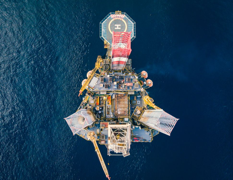
IRIS provides fully remote, onshore Positioning QC services for dynamically positioned Mobile Offshore Drilling Units (MODUs), including drillships, semi-submersibles, and jack-up rigs. By combining proprietary V-Node positioning hardware with the IRIS web mapping application, authorised clients and Positioning QC specialists can verify that a drilling unit is correctly located at the well location - in real time, from anywhere - without the need for dedicated personnel onboard.
The challenge
Before a deepwater well can be spudded, the operator must obtain independent verification that the drilling unit is positioned within approved tolerances at the target well location. This is a critical safety and regulatory requirement that applies at every well across a drilling campaign.
Traditionally this has required a positioning specialist to be physically mobilised to the rig for each well move - adding cost, logistics, and HSE exposure for every location change across a campaign that may span months and multiple wells.
How IRIS delivers remote Positioning QC
IRIS supports a fully onshore delivery model built around three components that work together seamlessly.
V-Node hardware
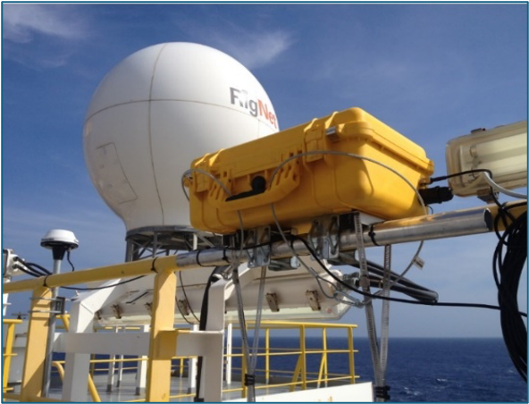
Vysus' proprietary V-Node units are permanently mobilised aboard the MODU. Each unit contains:
- High-accuracy DGNSS position and heading sensors
- An AIS receiver providing an independent layer of vessel identification and position
- Interface to the rig's APOS dynamic positioning system, consuming the rig's own independently computed positions for the drillship, ROV, and seabed beacons
Two V-Node units are typically deployed, providing redundancy and cross-check capability. Data is transmitted from the rig to the IRIS cloud data warehouse via Iridium satellite, 4G modem, or the vessel's own network - whichever link is available.
IRIS web mapping
Incoming V-Node data feeds directly into the IRIS web application, where it is processed in real time. IRIS independently computes the drill-centre position and compares it against the target well location, displaying:
- All active position sources (DGNSS, USBL, ROV, seabed beacons) simultaneously on the web map
- Position tolerance circles overlaid on the well target
- Seabed infrastructure layers (pipelines, cables, existing wells) for situational awareness
- Nearby vessel positions via AIS, including support vessels and supply boats
- Historical track replay - every rig move can be reviewed in full after the event
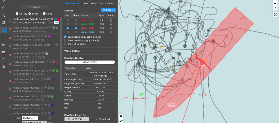
Authorised COMPANY users can access the IRIS web map directly, giving the client's own drilling team and wells engineers independent visibility of positioning status throughout each move.
Onshore Positioning QC oversight
A Vysus Positioning QC Specialist monitors the move from onshore using IRIS, providing 24/7 support for the duration of each rig move. The specialist:
- Prepares and coordinates approval of a well-specific Task Plan with the rig team prior to each move
- Liaises with the Senior Drilling Supervisor (SDSV), Dynamic Positioning Operators (DPOs), and ROV Supervisors throughout the move
- Monitors interim position solutions and data quality as the rig approaches location
- Confirms spud location once the drill-centre is within approved tolerance
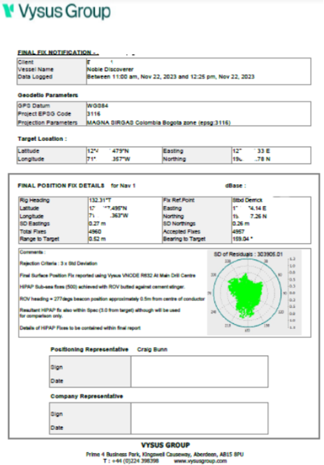
- Issues the Final Fix Notification Report - a formal position confirmation document signed by the Positioning QC Specialist and the Company Representative - for each well
What IRIS monitors
| Source | Description |
|---|---|
| V-Node DGNSS | Independent high-accuracy surface position and heading at the main drill centre |
| APOS DP position | Rig's own independently computed position (cross-checked against V-Node) |
| USBL / HiPAP | Underwater acoustic positioning of ROV and seabed beacons |
| AIS | Independent vessel identification and position verification |
| Seabed beacons | Deployed marker positions for drill-centre verification |
The well move workflow
A structured, pre-approved process governs every well move:
- Pre-mobilisation desktop audit - review of existing calibrations, installation reports, APOS configuration, and surface/underwater system setup
- Task Plan preparation - well-specific plan approved by all parties (Drilling, DPOs, Vysus) before move begins
- Pre-move kick-off - virtual briefing with rig team to confirm procedures and communication protocols
- Through-move monitoring - 24/7 IRIS-based oversight of interim positions, data quality, and tolerance status throughout the move
- Spud confirmation - formal confirmation once the drill-centre is on location within tolerance
- Final Fix Notification Report - position confirmation document issued for approval
- Post-move wash-up - lessons learned review before the next well
Permanent installation advantage
Where V-Node equipment is permanently mobilised aboard a rig across successive campaigns, the benefits compound:
- No recurring mobilisation cost - equipment is always available, reducing per-well overheads
- Faster readiness - no equipment shipping, installation, or offset measurement required before each campaign
- Institutional knowledge - the Positioning QC team builds a detailed understanding of the specific rig's systems, calibrations, and quirks over time
- Continuity of data - a full positioning history for every well drilled by that unit is retained in IRIS, available for replay and reference
Key capabilities
Remote delivery
The entire Positioning QC service is delivered from onshore. No Vysus personnel are required on the rig for each well move, reducing cost and HSE exposure while maintaining - and in many respects improving - the standard of independent QC oversight.
Client access
Authorised client users are granted direct access to the IRIS web map and can monitor the move onto location in real time and replay mode, independent of the Vysus team.
Auditable record
Every well move, interim position solution, and final fix is recorded in IRIS. The Final Fix Notification Report and the full positioning dataset for each well are permanently retained and available for review.
Supported rig types
IRIS Positioning QC is applicable to any DP-capable MODU with permanent positioning systems installed and operating:
- Drillships - dynamically positioned, deepwater
- Semi-submersibles - DP or moored, mid- to deepwater
- Jack-up rigs - where positioning QC is required prior to jacking and spudding
Related IRIS capabilities
- Vessel Tracking - real-time and historical vessel positions on the IRIS web map
- Project Management - live project progress, DPR access, and QA/QC reporting
- Metocean - hindcast and forecast environmental conditions at the development site