
Vessel Tracking
Vessels Module
The Vessels module can be accessed using the vessel icon on the left-hand pane. This can be used to view and configure everything about vessels/vehicles within the current project. These may include survey, guard and fishing vessels, onshore teams, subsea ROVs/Trenchers etc.
Sources
IRIS can retrieve positional data from a variety of sources including but not limited to:
- Terrestrial or Satellite AIS from an online provider either as individual vessels or area feeds (
AIS). - Project vessel navigation systems (
NAV). - Vysus Group's handheld
Iridium GPS Tracker(TRK) (a.k.a, Yellowbrick or Bluebrick). - Vysus Group's onboard V-Node system (
NAV). - API services and UDP/TCP port messages.
For more information and to get new vessels tracked contact the IRIS team
Layout
The top tabs group the vessels by status:
- Project - Any vessels related to the project
- Non Project - Vessels working in the vicinity but not related to the project
- Legacy - Older vessels that used to work on the project
- Other - Nearby vessels, usually recieved via AIS or an area feed.
Vessels are then listed in Groups by type e.g. fishing, survey, guard etc.
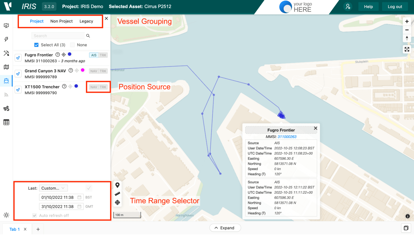
Each vessel has a number of buttons. From left to right: 
Tick/Cross- Enable disable vesselQuestion Mark- Information on the current vesselLocate- Zoom to vessel locationSettings Cog- Vessel settings and configurationColour Picker- Temporarily change vessel colourSource Toggle- Toggle between position sources if available. This can include AIS/TRK/NAV
At the bottom of the module you have the time range selector. This has some quick predefined options e.g. last 24 hours or you can set a start and end date to look at historical vessel tracks. If there are a lot of vessels enabled in a project try not to select more than a month of data or turn off other vessels. 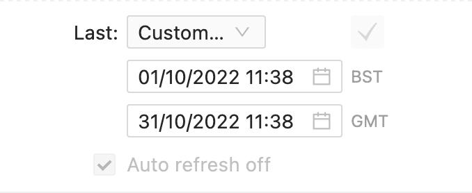
On the map you can click each node along a vessel track to show a popup window detailing the position details which include source, UTC and local time, easting, northings, speed and heading.
Typically the TRK is configured to provide hourly location updates. NAV positions should be up to 2 minutes apart and AIS up to 5 minutes apart. Invariably, positions transmissions can stop for a number of reasons e.g. Vessel out of AIS range, TRK device battery dead, onboard NAV systems restarted and feed not back online. This is why it is best practise to use multiple sources. If you suspect a problem with one of the feeds contact the IRIS team.
Vessel Settings and Configuration
The vessel settings and configuration panel will be available for specific projects and vessels and may have up to 3 tabs:
- Info
- Offsets
- Computations
Info
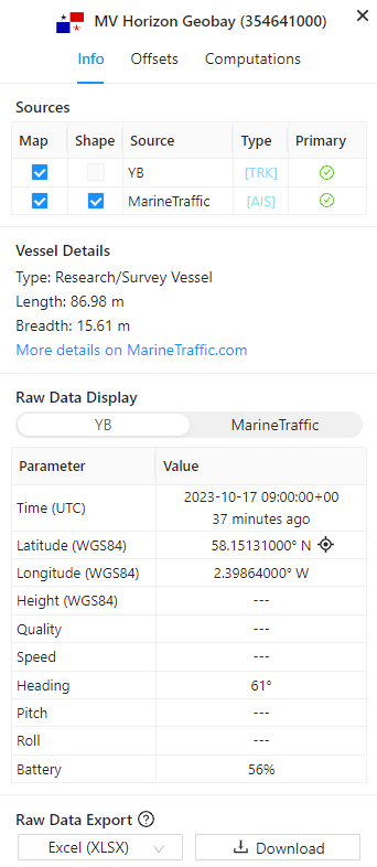
Here you will see the sources used to track this vessel, you can enable/disable each source to view a specific source if needed.
This tab also contains the raw data display where you can see the raw infomation for each source as receieved by IRIS. You can also download all raw data for the selected time frame in CSV, XLSX or GeoJSON formats. Note: MarineTraffic exports are disabled.
Offsets
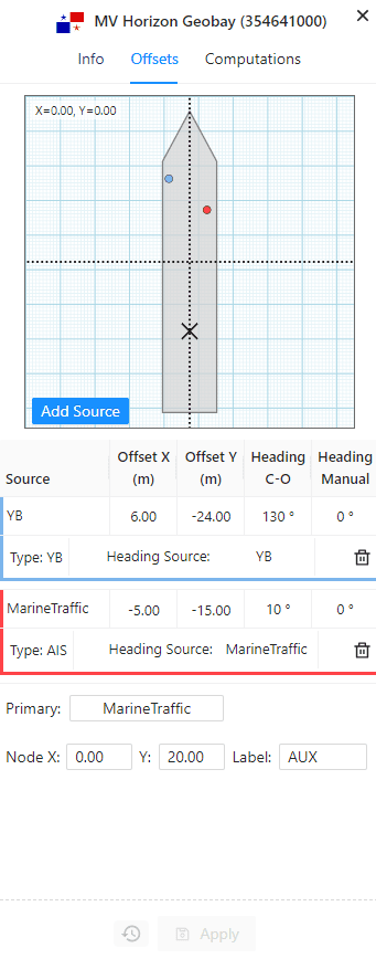
This tab allows you to set the offsets for each source in relation to the CRP (dashed crosshairs). You can also specify any heading corrections or set a manual heading value if needed.
If the node X and Y are set, it will appear on the chart as a black X.
If offsets/node are applied they will then appear on the vessel shape on the map

Computations
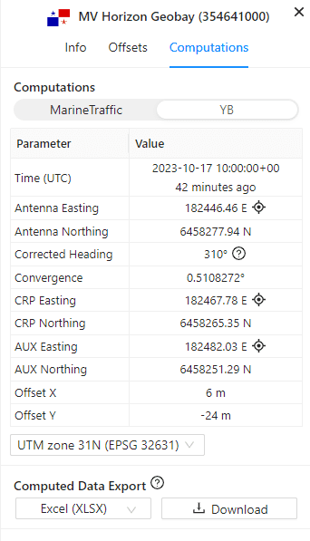
The computations tab shows the latest calculated position for each source based on the applied offsets, convergenge and heading correction. The coordinates can be displayed in WGS84 lat/lng or the project UTM zone. All computed positions can be exported for the selected time range in both lat/lng and easting/northing.